Types of ZSR
Biodiversity
How ZSR can be implemented:
- Site selection, planning and construction of SEZ infrastructure and associated ports, as well as construction of factories within zones, should take account of potential biodiversity impacts and mitigate negative effects.
- Regulators should specify due diligence requirements and carry out genuine environmental impact assessments (EIAs) to assess and mitigate long-term impacts of SEZ establishment for biodiversity.
- Compensation should be offered to those whose livelihoods are affected by the loss of biodiversity resulting from SEZ construction and operation. Companies investing in the SEZs could support affected locals through corporate social responsibility activities.
- In areas of special biodiversity or where endangered species are present, natural parks or protected areas should be established to prevent biodiversity loss and to promote awareness of the threat to ecosystems.
Overview of the problem:
The development of SEZs may come at the cost of valuable environmental habitats such as, forests, rivers and mangroves, as well as the varied forms of life that they host. SEZ establishment, without consideration of the existing biodiversity of the region, and the implementation of effective mitigation measures,, can interfere with ecosystem balance, causing long-lasting negative impacts. Some of these impacts are difficult to estimate, owing to the complex inter-dependence of life among people, flora and fauna.
As SEZs require large-scale acquisition of land, it is often impossible to avoid some forms of ecosystem damage. These projects may not only destroy wildlife habitats, but also disrupt migration routes or split animal populations, with long-lasting impacts. The impact on endangered species can cause irreversible loss to natural heritage of the area, and harming nature-based tourism, a potentially important source of income for the region. Coastal regions and wetlands are particularly sensitive to changes. SEZ-related construction and manufacturing in such areas canimpact local biodiversity, such as through sand mining, logging and construction of dams,
While biodiversity is an important end in itself and requires protection, its loss can also lead to negative impacts for the SEZ. The destruction of mangroves, for example, can cause flooding which may affect the SEZ’s territory as well as the broader local area.
Manufacturing inside the SEZ may have multiple dependencies on local ecosystems, including on water and biological raw materials such as fibres and foods, both directly at the factory level and indirectly through the supply chain. Relationships with local ecosystems can thus be diverse and complex, with industrial production not only creating harms to biodiversity but also potentially suffering harms from ecological degradation.
Examples:
The construction of the Adani Port and SEZ at Mundra led to widespread destruction of mangroves along the Gujarat coast. This created a collapse in the ecosystem, as local pastoral communities (maaldhaaris) could no longer graze camels on the mangroves, and migrated out of the region or ceased camel rearing (Tamali, et al., 2013). Damage to coastal flora and fauna increased the chances of flooding, while the desalination of sea water and the pumping of wastewater into local soils lowered the quality of produce grown in the area, with dates, chikoo fruit, and mangoes all deteriorating in quality (Sunita Narain Committee Report, 2013). In 2018, the Gujarat Institute of Desert Ecology started restoration efforts to build a Mangrove Biodiversity Park in the area (Khakhariya, 2022). The efforts have increased stakeholder participation between local communities, government and private playersthe APSEZ, leading to restoration of nearly 3000 hectares of mangroves in Mundra from 700 hectares in 2006asuccessful outcomeas recorded in recent scientific evaluations (Ramesh & Shah, 2022; Padma, 2022).
New construction of infrastructure along the coast in Kribi has created stress for the ocean, causing higher waves towards the mainland in recent years (Toto, 2024). The image below shows land use change in the Kribi Deep Sea Port in Cameroon.
Land use and land change for Kribi Deep Sea Port and associated SEZ (2000–20)

Source: GIS mapping, King’s College London
The Port Authority of Kribi constructed a dike in 2014 which softened waves but did not mitigate erosion, as a result of which the coast has shrunk by 2 metres per year since the port became operational (Fendoung et al., 2022). This erosion has increased the frequency of flooding. While the dike has seen some parts gain an additional 15 metres of sand, other areas have lost just as much, creating a jagged coastline. Coastal regions such as Kribi are particularly vulnerable to climate change and sea level rise, with serious detrimental effects.
Local beaches and related biodiversity have been negatively impacted by such changes, as is the wildlife in Cameroon’s only marine protected area, Manyange na Elombo-Campo National Marine Park, which is just 30km from Kribi port and is reliant on beaches and sea for lifecycle completion (Romain et al., 2017; Okafor-Yarwood et al., 2020). The protected area is home to three turtle species that face escalating levels of threat: olive ridley (vulnerable), green (endangered) and hawksbill turtles (critically endangered). Rising oil pollution in sea waters has led to the decline of these three endangered species of turtles in Kribi (Toto, 2024).
The Cameroonian coast is rich in protective mangroves. However, as migrants from other parts of Cameroon have arrived to work in the SEZ, a rapid increase in human settlements has put pressure on housing and fuel, both of which affect the mangroves through increases in sand-mining for construction and rapid consumption of mangrove wood for fuel (Toto, 2024).
Before the construction of Lekki Port, an Environmental Impact Assessment (EIA) was conducted, predicting adverse impacts on fishing during dredging and marine infrastructure construction. The EIA observed that the project would harm the terrestrial ecosystem of the local vegetation, soil and wildlife habitat, and highlighted an adverse impact on the marine ecosystem resulting from the maritime shipping activity, noting that the landscape’s biodiversity would also be in danger, primarily due to increased urbanisation (Goodwill House, 2010). The EIA document set out substantial commitments to mitigating environmental hazards on the Lekki shore. Yet the impacts on local fishing communities have been severe, with limited mitigation put in place. These impacts stem not only from the port construction but also from the Lekki Free Zone itself, the construction and operation of the Dangote oil refinery, and the adjacent Lagos Free Zone.
Fish have become scarcer, not only in the ocean but further inland in the Lekki lagoon – most likely a result of the sand-filling that has changed the local ecosystem (Goodburn, Knoerich, Mishra & Calabrese, 2024). Swamp lakes in Idotun, a village on the Lekki peninsula, have dried up, as a result of the construction of the port, since construction engineers sand-filled the lake to level the ground for creation of a dock area. In Idotun and Magbon Segun communities, palm and coconut trees have also died since the drying of the lakes (Goodburn, Knoerich, Mishra & Calabrese, 2024).
Satellite images show not only the compromised lake ecosystem, but also large-scale destruction of mangrove vegetation in the area. Riverine mangrove vegetation in Lekki decreased from about 7 to 2.5 acres between 2015 and 2023 (Adeyemi, 2023). This destruction has caused enhanced flooding in many villages of Ibeju-Lekki, and worsened by the barriers to erosion erected to guard the port, which have redirected erosion towards local communities.
Some CSR activities by the zone have targeted local fishing communities, for example by providing nets and outboard motors (Goodburn, Knoerich, Mishra & Calabrese, 2024). Reports also suggest that some fishermen were compensated for the damage caused by the construction of the port, and that palliative outreach was provided to villagers during COVID-19 (LFZDC, 2020). Yet the response has been inadequate to address the long-term damage to the local ecosystem and major damage to local livelihoods, with many people no longer able to depend on fishing or coconut or palm farming for the majority of their income.
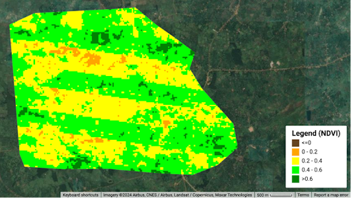
The images below demonstrate the progression of the normalised difference vegetation index (NDVI) from a higher extent of vegetation (greener hues) to a lower extent (yellow to orange hues). The NDVI is calculated on a scale of –1 to +1, using the difference between light reflected by vegetation cover and light absorbed by vegetation cover. This helps to capture the changes in vegetation cover and intensity. The images below demonstrate an extreme reduction in vegetation cover closer to the coastline where the Lekki Free Zone is based.
Normalised difference vegetation index (NDVI)


Source: GIS mapping, King’s College London
Uganda’s Liaoshen Industrial Park has experienced some of the typical environmental impacts from intensified urbanisation and factory construction. The figure below demonstrates the land use shifts from an agriculture-dominant landscape to a built-up area of factories with some remaining shrubs in the immediate vicinity of the park.
Land use changes from 2000–20

Source: GIS mapping, King’s College London
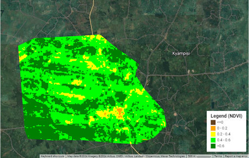
The images below shows that vegetation cover has reduced over the years due to industrial activity and urbanisation. In the broader Nakaseke District, though (not shown in the figure), agricultural activity has increased owing to enhanced demand for agricultural produce created by the expanding population and food processing activities within Liaoshen Industrial Park.
Normalised difference vegetation index (NDVI), Liaoshen Industrial Park

(2003)

(2006)

(2014)

(2023)
Source: GIS mapping, King’s College London
The case of China:
During initial rapid expansion from 1980, China’s first SEZs and particularly Shenzhen showed little concern for protection of biodiversity. The transformation from fishing villages to megacity was driven by the rapid conversion of forested areas, which decreased 300% by 2020 (Cheng et al. 2023), as well as the conversion of agricultural land.
However, more recently Shenzhen’s local government has sought to reposition the city for a new phase of growth based around industrial upgrading and the enhancement of the quality of urban environment (SUPB & UPDIS, 2005). From the early 2000s the city’s environmental strategy included a concerted framework of ecological protection through the ‘Basic Ecological Control Line’ policy, which placed 974 km2 of land within the city under strict statutory preservation measures. This land includes water source protection areas, scenic areas, natural protection areas, forest and country parks, mountains, highlands, reservoirs, wetlands and ecological corridors (Lin & While, 2022). This policy shift indicates not only increased state attention to ecologically sustainable development, but also the role that effective environmental policy might play in attracting higher value, less ecologically damaging economic sectors to the city. However, the social impacts of such a large ‘control line’ reservation have been more mixed, with some displacement of residents and restrictions on community industries in the newly demarcated area.
China-associated zones overseas
A recent report on Chinese overseas projects, including SEZs, assessed potential risks to biodiversity based on the locations of the projects (Springer et al., 2023). It found that some China-associated SEZs pose a higher-than-average risk to biodiversity, highlighting the TEDA-Suez project as of particular concern. On average, Chinese projects have been found to pose a slightly higher risk to biodiversity compared to the average risks for World Bank projects (Yang et al., 2021). However, this might relate to the specific sectors in which Chinese investment has been concentrated. The extent to which Chinese firms operating overseas respect environmental norms, including on biodiversity protection, typically depend on the institutional capacity of the host country and its ability to implement laws and regulations promoting environmental standards, though the Chinese state has also increasingly sought to raise standards for Chinese projects abroad. For SEZs in particular, zone managers and individual enterprises within the SEZ are the main actors in environmental governance, and the extent to which they face Chinese state regulation may depend on their nature. Where these are privately-owned firms, they are less likely than China’s state-owned enterprises to be regulated on their environmental practices (Springer et al., 2023).
Further reading
Mazhar, S. (2016). Special Economic Zones (SEZs) and Sustainable Development. International Journal of Research in Social Sciences, 6(2), 141-152.

